

On 20th May 2010, the United Nation’s 64th President of the general Assembly, Ali Triki was in Yaounde . He handed to President Paul two beautiful maps. This was reported by CRTV and the State-owned Cameroon Tribune. The Presidential gift to Biya at the Unity Palace was a two well-framed maps- a large framed map of La Republique du Cameroon, with an international boundary separating LRC and the Southern Cameroons. The second was the map of the British Cameroons, with an international boundary separating the Southern Cameroons and Northern Cameroons.
George Ewane , who reported said “Apart from the Map of the Republic of Cameroun is that of British Southern Cameroons” Joseph Le and Ephraim Banda Ghogomo at the studio cut in to ask “What did you say?” And George could commented no more. So he allowed the microphone to overhear what Mr. Ali Triki was saying.., Voici la carte du Cameroun Britannique…histoire en a decidee”
Some Background Information
La Republique du Cameroun had her independence on January 1, 1960. The boundaries as of that date were determined, established and recorded at the Secretariat of the United Nations in New York. As of that day, the Southern Cameroons and Northern Cameroons were still under the trusteeship of Britain, being prepared for eventual independence. Its flag was Green Red Yellow and its National Anthem, reflecting the savagery of LRC was made public. Its first President was Mr. Ahmadou Ahidjo.


On February 11, 1961, the Southern Cameroons voted in a UN-organized plebiscite to have her independence in a defined union with LRC, while Northern Cameroons did so, but to unite with the Federal Republic of Nigeria. Nigeria remains a federation as of that pact signed in 1961, while the Southern Cameroons remains annexed, given that the proceeds from the 1961 plebiscite were never formalized in a Union Treaty to be deposited at the Secretariat of the United Nations as per U.N Charter, which makes it very clear that if two nations come into an understanding to change their original international boundaries in the form of any mergence, it must do so with the knowledge of the United nations and both will sign a Union pact which must be deposited at the U.N Secretariat.
But, history has it that by June/July of 1961, La Republique du Cameroun invited the Southern Cameroons, through its Prime Minister, John Ngu Foncha, to attend a Conference in Foumban in LRC where they were to discuss the Constitution of a future United Cameroons in a federal structure. Was this to go along smoothly, there was to be a signing ceremony whose outcome was to be related to the United Nations as per UN Charter Article 102(b)? Alas, this never happened as LRC’s foul play was uncovered. Foumban ended in a still birth.
So, by October 1, 1961, Britain was itchy to quit the soils of Southern Cameroons. J.O. Field had packed his bags and baggage and his boat were steaming, ready to take off. Southern Cameroons was to be officially declared an independent state, to assert its future. What happened at today is Bongo Square was a horrible mess “an open hijacking of the independence of a people. When the Union Jack was lowered, Ahidjo’s green Red Yellow was raised and LRC’s Savage Anthem chanted in French!! Foncha was helpless and vulnerable.
That notwithstanding, the independence was declared, and only hijacked. It was like a slave being freed by one slave master, and on his way home, he is enslaved by another slave master.
ENTER THE TWO MAPS
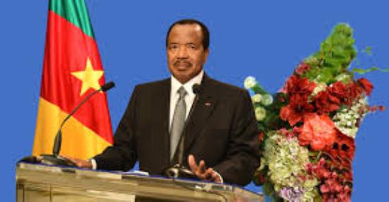
So, what were the two maps that the UN representative handed to Biya in Yaounde on May 20, 2010? According to live reports from CRTV monitored in Bamenda, the UN representative, Ali Triki, who was the President of the 64th General Assembly of the UN, in handing the two maps to Cameroun’s Head of State, declared “Voici les cartes de Cameroon Britannique…histoire en a decidee ( Here are the maps of British Cameroons…history had so decided..”. According to another State-owned media, Cameroon Tribune of Tuesday, May 25, 2010, on page 1 and 3, carrying the pictures of the two maps in the presence of Paul Biya and Jean Victor Nkolo, who was of the Information Department at the UN, the two maps were well framed, large enough for Biya to understand even from twenty meters away.
WHAT IS AT STAKE?
The United Nations came and attended the 50th anniversary of LRC, and, by the gift of these two maps, the UN was informing the Yaounde authorities that the same UN has not forgotten the people of Southern Cameroons. Is the UN acknowledging, in a diplomatic manner that Yaounde and Buea have some unfinished works at the UN’s Secretariat?
Presently Southern Cameroonians are protesting and there are loud voices of Independence being echoed across all cities in Southern Cameroons.
BaretaNews Statement:
The handing of the two maps was a very significant move from the UN. What did the people of Southern Cameroons do to capitalised on this move? The United Nations will never help Southern Cameroons if the people themselves do not make bold moves that will warrant the attention of the international world. Southern Cameroons movement must try as much as possible to exploit these opportunities. The current stakes of events in the country should remind us that we must go an extra mile if we need Independence. The UN as a diplomatic body will only come when things are soar. The future lies with us.
God is still saying something?
Part of text culled from Ntemfag Ofege’s blog


1 comment
The only way to end this stupid unrecognized and undefined union with The Republic Cameroon is by declaring a return to the post plebiscite autonomy enjoyed by Southern Cameroons.. By reverting to that autonomy is to demand thatthe government of The Republic of Cameroon return to the state of affairs where the Foumban Conference left off.. If all the statements made by the SCNC, Ambazonia, UNO State of Cameroon are true let them all agree that no legislative decision or decree – whether signed by Ahmadou Ahidjo or Paul Biya were ever supposed to have any effect on Southern Cameroons because the Foumbal talks were not concluded with any signed agreement between Southern Cameroons and the Republic of Cameroon. Because of that no action taken by The Republic of Cameroon was ever supposed to have any effect on the Southern Cameroons. and that is the official situation that continues to exist to this day. A set of dossiers should be compiled including (1)A written disclaimer from the UNGS that there is no signed agreement to form any kind United country or federation by Southern Cameroons and the Republic of Cameroon and sent in for registration in the UNGS (2)That there is no such document in existence in the first place and the burden is on the Republic of Cameroon to disprove this assertion (3) This dossier should include a very clear and elaborate administrative structure – from the executive through the legislature and judiciary down to the local governments. (4) It should also include the type of currency Southern Cameroons would return to since a pre Foumban conference currency was the the Pound Sterling.(5) Identification documents to be used must be included. (6) The document must be completed with the pledge that Southern cameroon delegates are ready conclude the Foumban talks as United Nations had demanded to happen after the official plebiscite results were announced.. . This dossier would be made public and circulated as widely as possible both inside Cameroon and the world at large and most importantly to every diplomatic mission in Cameroon today. After satisfying itself that enough publicity has been done the Southern Cameroons should declare it has reverted to the post 1961 Plebiscite situation as well as ready to continue the the yet unconcluded Fouman talks. This is the only way forward. It is a common sense approach. If there is no signed agreement to form a union between two countries, why pretend there is any connection between the two? And so what do we need the UN for to revert to the pre Foumban talks situation? We should just expose the bitter truth and tell the world that we are going home and then we go.. What else do we expect the UN to do for Southern Cameroons now? Our former leaders naively stood without raising any objection when the Republic of Cameroon sent its troops to occupy Southern Cameroons and Ahidjo started signing one decree after another forcing us through military force to accept whatever he wanted. But regardless of how many decrees he signed, regardless of the fact that he violated our autonomy, no matter how much he did to alter our political structure and by eventually eliminating it completely, nothing he unilaterally did could change the situation we had before entering the Foumban talks. Whatever he did was to suspend our political evolution. He could never obliterate it. Only a joint agreement between the two territories could do that and there is no such document to prove that ever happened. I don’t see how the UN has anything to do with that anymore.